





Space Situational Awareness and the UAE’s Role in a Crowded Orbit
Executive Summary
Satellites now underpin communications, navigation, weather forecasting, agriculture, disaster response and national security. Active satellites have multiplied roughly fivefold in five years, driven largely by commercial broadband constellations, and the orbits they occupy are filling faster than ever before. Around the satellites circulate millions of fragments of debris, most too small to track and all capable of disabling a spacecraft on impact.
Operating safely in this congested environment requires Space Situational Awareness (SSA): the ability to observe objects in orbit, understand what they are, and predict where they will be. Today, much of the world depends on a small number of national catalogues and commercial providers for that picture.
The Technology Innovation Institute (TII) is building a sovereign UAE capability across the full SSA chain. It starts with sensing, using neuromorphic event-based cameras alongside conventional optical telescopes. It continues through object identification and precise orbit determination and extends to decision support for operators facing a collision risk. The next step is scale: a wider ground network, including sites in the Southern hemisphere and ultimately, observation from orbit.
SSA is a strategically important capability for the UAE. It protects a growing national satellite fleet, creates a commercial data and services market, and positions the UAE as an independent, trusted contributor to the global effort to keep orbital space usable for every nation.
This paper sets out the SSA challenge facing the UAE and every other spacefaring nation. It describes the capability TII is building across the full SSA chain, from neuromorphic event-based sensing through orbit determination to decision support, and the path to scaling it from a national ground network to observation from orbit. It closes with what this capability offers UAE operators, industry and international community.
1. Introduction: A Crowded Orbit
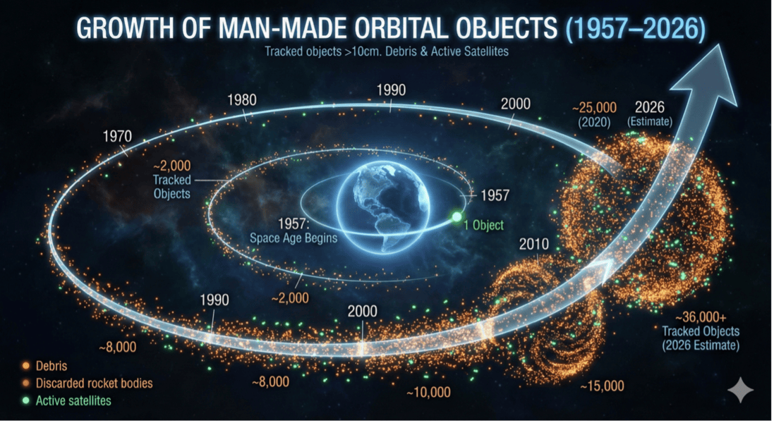
At the start of 2020 there were roughly 3,000 active satellites in orbit. Today there are more than 14,000.
Most of that growth stems from a single new use: constellations that provide internet access anywhere on Earth. Starlink alone has more than 9,000 satellites in orbit. Others are following: China’s SpaceSail plans up to 15,000 satellites; Amazon Leo is licensed for 3,236; and Blue Origin’s TeraWave plans around 5,400 for government and enterprise data services.
Satellites are not the only objects in these orbits. Six decades of launches have left spent rocket stages, defunct spacecraft and fragments from explosions and collisions. Most of these travel at around 28,000 kilometers per hour in low Earth orbit. At that speed, a fragment the size of a paint fleck carries enough energy to crack a window, and a centimeter-scale fragment can disable a satellite.
Estimates of the debris population:
- About 40,000 objects larger than 10 centimeters are tracked and catalogued. Around 14,000 of these are active satellites.
- About 1.2 million objects between 1 and 10 centimeters are too small to track individually.
- Well over 100 million objects between 1 millimeter and 1 centimeter can only be estimated statistically.
The Orbital Zones
Low Earth Orbit (LEO): extends from 160km above Earth to 2,000km. This is where constellations of satellites are found as well as many weather satellites and geoimaging satellites.
Medium Earth Orbit (MEO): between 2,000km and 36,000km above Earth. This wide region is preferred for navigation satellites, many kinds of scientific research and for satellites that monitor debris in orbit.
Geostationary Earth Orbit (GEO): 35,786km high allowing the satellite to exactly match the speed of the Earth’s rotation and remain above a single location on the ground. This is useful for telecommunications, weather, and surveillance.
The risk is no longer theoretical. In November 2025, the return of three crew members from China’s Tiangong station was delayed after a small crack was found in a window of their return vehicle, Shenzhou-20. The China Manned Space Agency attributed the crack to a suspected debris impact. The crew returned nine days late aboard a different spacecraft.
Both Tiangong and the International Space Station routinely maneuver to avoid tracked debris. The larger concern is a cascade where one collision produces thousands of fragments, each capable of causing further collisions. Past a certain density of debris, parts of low Earth orbit could become too hazardous to use.
Orbit is also contested. More than two dozen nations operate military satellites. Commercial imagery now plays a visible role in how the world understands unfolding crises. Destructive anti-satellite tests conducted since 2007 have added thousands of tracked fragments to the debris population, some of which remain in orbit. For any nations with assets in orbit, knowing what is up there, and what is up there, and what it is doing, is a matter of national interest as well as safety.
Certain orbits are also scarce, such as the geostationary belt and specific sun-synchronous altitudes. Without transparent, shared awareness of who occupies them, the use of near-Earth space risks becoming unmanaged and unsustainable.
2. Observe, Understand, Predict
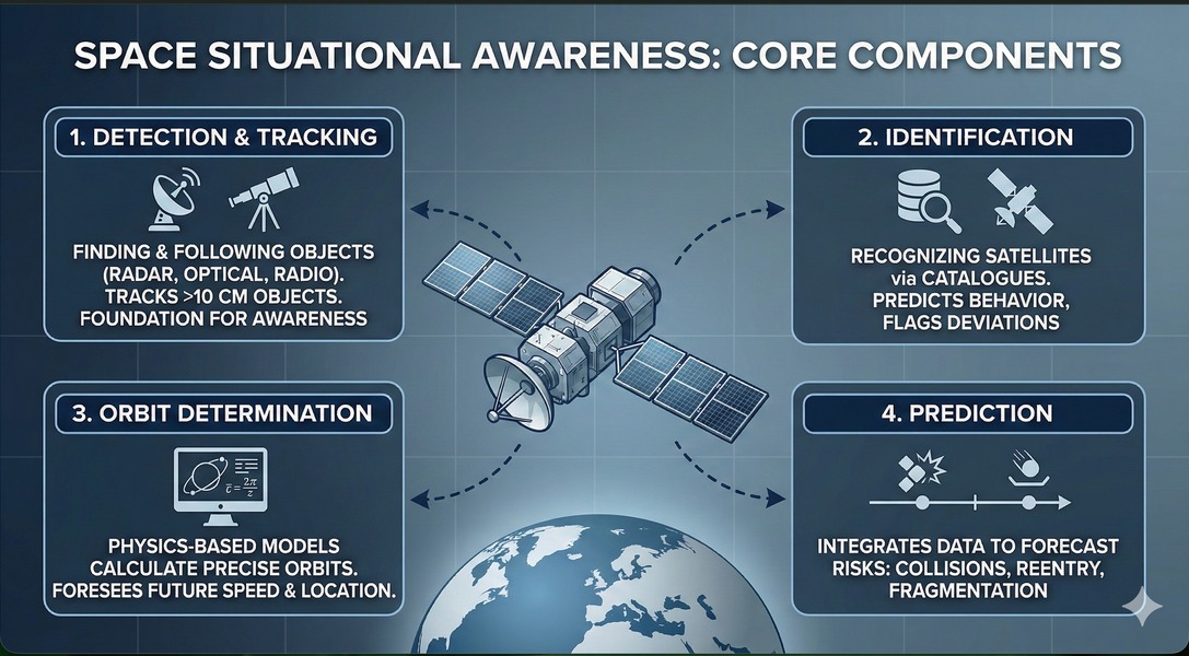
SSA is commonly described as a chain of three stages. Each depends on the one before.
Observe: Sensors detect objects and measure their positions over time.
Understand: Observations are matched to known objects and orbits are calculated from them. Objects are identified by correlating observations against catalogues of known objects. The most widely used is the public catalogue maintained by the US Space Force, available through Space-Track.org. It is supplemented by data from the European Space Agency, national agencies, commercial providers such as LeoLabs, and research institutions such as the Astronomical Institute of the University of Bern. The UN Office for Outer Space Affairs maintains the register of objects that states have formally launched.
Predict: Orbits are propagated forward to forecast close approaches, reentries and breakups. The results are turned into decisions: whether an operator should maneuver and how.
How objects are observed
No single sensor type sees everything.
Optical telescopes detect sunlight reflected from objects in orbit. They are passive, which makes them relatively inexpensive to run, and they work across all orbital regimes. Their limits are practical. Clouds and light pollution block them and timing matters. An object in low Earth orbit is visible only when the telescope is in darkness and the object is still sunlit, which largely confines observation to the hours after dusk and before dawn. Geostationary objects, much higher, remain sunlit and can be observed through most of the night.
Radar transmits its own signal. It works day and night in most weather and it measures range and velocity directly. It is used mainly for low Earth orbit, because signal strength falls away steeply with distance and only a few very high-power systems reach geostationary altitudes. Radar also has blind spots: each station sees only what is above its horizon, so coverage depends on where stations are built. Transmitting makes radar far more expensive to operate than optical systems.
Radio-frequency monitoring listens for transmissions from satellites. It is useful for identifying and characterizing active spacecraft, but by definition it cannot detect debris, defunct satellites, or satellites that are not transmitting.
Space-based sensors remove the constraints of weather, daylight and horizon by observing from orbit. Their use has grown in recent years and is now a priority for several national SSA programs.
Two factors complicate every stage. The first is the space environment. Solar activity heats and expands the upper atmosphere, increasing drag on satellites in low Earth orbit. In February 2022, a geomagnetic storm caused 38 newly launched Starlink satellites to reenter before they could raise their orbits. The second is volume. The catalogue is growing faster than traditional methods can process it. Artificial intelligence is increasingly used to detect objects in noisy data, flag unexpected maneuvers, and model how atmospheric conditions will affect drag in near real time. It is also used to decide where limited sensors should be pointed next.
3. TII’s Chain from Sensing to Decision
TII’s SSA program is built to cover the chain end to end rather than to specialize in one stage of it. Its distinctive contribution begins at the first stage with how objects are observed.
Neuromorphic event-based sensing
Conventional astronomical cameras capture full frames at fixed intervals. Every pixel is read out every time, whether anything in the scene has changed or not.
Neuromorphic event-based cameras, so-called because their design is inspired by the retina, work differently. Each pixel operates independently and reports only when the brightness it sees changes. Each change is reported the moment it happens, with timing resolved to the microsecond. The results include very high temporal resolution, a wide dynamic range so a faint object next to a bright one remains measurable, and far less data when the scene is static.
For SSA, these properties are important.
Timing
A satellite crossing the field of view generates a continuous stream of events rather than a streak smeared across a frame. That allows the moment it passes a given point to be measured far more precisely, and precise timing translates directly into better orbit determination.
Pairing with conventional frames
TII’s hybrid systems pair neuromorphic event cameras with conventional frame-based telescopes. The frames supply the background star field and object brightness. The event stream supplies the timing.
Extended observation windows
Because neuromorphic event sensors respond to change rather than absolute brightness, they offer a potential route beyond the twilight observing window that constrains conventional optical tracking.
TII’s optical work draws on the Abu Dhabi Quantum Optical Ground Station. The station was built to support satellite-based quantum key distribution, which uses laser links to establish encryption keys whose interception is physically detectable. It requires precise laser tracking of satellites, a capability that transfers directly to SSA. Researchers at the station now work with TII’s space research teams to track resident space objects, collect orbit-determination data, and investigate laser ranging for future orbit-monitoring applications.
Identification and characterization
TII is developing deep learning models to detect and classify objects in orbit, distinguishing active satellites, spent rocket stages and debris fragments. The same work extends to behavior: recognizing maneuvers, changes in rotation, and anomalies in an object’s motion faster than an analyst could. An object that deviates from its expected path or begins to tumble is often the first sign of a failure, breakup or deliberate maneuver.
Active satellites that report their own positions can be tracked by comparing where they say they are with where they are observed. Tracking is much harder for the tens of thousands of catalogued objects that do not report. Identification and orbit determination for these objects rely entirely on independent observation.
Precise orbit determination
Precise orbit determination (POD) combines observations taken at different times and places into an accurate estimate of an object’s position and velocity over time: its ephemeris. The calculation must account for atmospheric drag, solar activity and the uneven pull of the Earth’s gravity, as well as the object’s own motion. Every observation carries noise.
TII’s algorithms will refine multiple noisy observations into precise ephemerides for both reporting and non-reporting objects. These are the basis for collision screening, reentry prediction and mission planning.
Two research projects extend this work. The first addresses scale. An orbital propagator calculates an object’s future position from its current state. Propagating thousands of satellites in a single constellation and screening each against every other object is computationally heavy. TII is using data from a subset of a constellation to generate training data for AI models that predict the behavior of the whole group, at a fraction of the computational cost.
The second is physics-informed neural networks. Most machine and deep learning models learn only from patterns in past data. These models also build the governing laws of orbital mechanics into their structure, which makes their predictions more reliable when conditions move outside the domain of the training data.
Objects too small to track cannot have individual orbits determined but their collective distribution can still be modelled. TII will use AI to estimate where concentrations of untracked debris raise collision risk, identifying higher-risk orbital regions rather than individual threats.
Decision support
As the number of close approaches grows, operators need more than a warning, they need a recommendation. A conjunction alert tells an operator that two objects may pass dangerously close. It does not say whether a maneuver is warranted, when to make it, or how much fuel it will cost.
TII is developing decision-support systems that combine orbit predictions with information about the affected satellite’s propulsion and remaining fuel. From these, the systems generate specific maneuver recommendations. For UAE operators, this is the stage at which SSA data becomes directly protective of national assets.
TII currently operates ground-based optical and neuromorphic event-based observation from the UAE. It produces high-cadence, high-precision measurements of objects across low, medium and geostationary orbits. This data contributes to the global picture of the orbital environment and forms the foundation for the collision-screening and maneuver-planning services TII is developing.
4. Scaling the Capability
A single observation site sees only the sky above it and only when conditions allow. Coverage, and therefore accuracy, improves with the number and spread of sensors. The next phase of TII’s program addresses both.
A wider ground network
Most of the world’s SSA sensors sit in the Northern hemisphere, leaving gaps in coverage of southern skies. TII is working with universities and observatories internationally to extend its network of telescopes and neuromorphic event-based sensors, including sites in the Southern hemisphere. More sites mean shorter gaps between observations of each object, which directly tightens orbit predictions. The objective is continuous global coverage.
Observation from orbit
Ground-based sensing will always be contingent on weather, daylight and horizon. TII is studying options for space-based observation, from hosted payloads on other missions to a dedicated constellation of UAE microsatellites under 100 kilograms. Small satellites can be built in months rather than years, which lets new sensor technology be flown, tested and replaced on a short cycle.
A dedicated SSA constellation would serve UAE stakeholders directly and would also be a national contribution to global coverage. TII is also researching how space-based and ground-based data can be consolidated into a single secure picture as the foundation of any future system of traffic management in orbit.
5. Positioning the UAE
The UAE’s presence in orbit has grown from a single telecommunications satellite in 2000 to a fleet spanning communications, Earth observation, science, and defense, alongside missions to Mars and the Moon. That fleet, and the services that depend on it, is exposed to the same collision risk as every other operator.
A national SSA capability means UAE operators in government and industry do not depend solely on foreign or commercial sources for warnings about threats to their own assets. It also gives them independent verification of what those sources report.
But SSA data is only as useful as the trust operators place in it. As orbital traffic management moves from national practice to international coordination, independent and transparent sources of data will be increasingly valuable. The UAE is a spacefaring nation with working partnerships across the international space community. It can offer SSA data and services that operators around the world can rely on. Its contribution to global space sustainability, then, can be measured as much in shared data as in hardware in orbit.
The number of objects in orbit will keep rising. The satellites that modern life depends on will operate among more traffic and more debris every year. Nations that cannot see this environment for themselves will depend on others to see it for them.
TII is building that capability for the UAE across the full chain:
- Sensing, using neuromorphic event-based technology
- Identification and precise orbit determination, drawing on AI and physics-informed models
- Decision support that turns data into action
The UAE has the opportunity to become a leading participant in global Space Situational Awareness. It can protect its own assets, build a new commercial sector, and contribute data that every spacefaring nation can trust. TII invites partners and stakeholders to help shape a secure and sustainable future for orbital space.
Appendix 1
UAE Space Launches to Date
Satellite Name | Launch Year | Notes |
Thuraya-1 | 2000 | The UAE's first satellite, a mobile telecommunications satellite. |
Thuraya-2 | 2003 | Telecommunications satellite providing mobile satellite services. |
Thuraya-3 | 2008 | Telecommunications satellite expanding coverage to Asia and Australia. |
DubaiSat-1 | 2009 | The UAE's first government-owned Earth observation satellite. |
Yahsat-1A (Al Yah 1) | 2011 | The first satellite for Al Yah Satellite Communications Company (Yahsat), providing multi-purpose satellite solutions. |
Yahsat-1B (Al Yah 2) | 2012 | Yahsat's second satellite, providing broadband connectivity. |
DubaiSat-2 | 2013 | An advanced Earth observation satellite providing high-resolution imagery. |
Nayif-1 | 2017 | The UAE's first nanosatellite (CubeSat), developed by university students for educational purposes. |
Al Yah 3 | 2018 | A communications satellite expanding Yahsat's coverage to South America and Africa. |
KhalifaSat | 2018 | The first satellite developed entirely by Emirati engineers in the UAE. |
MYSAT-1 | 2018 | An educational CubeSat developed by students at Khalifa University, launched to the ISS and deployed in 2019. |
Falcon Eye 1 | 2019 | A military reconnaissance satellite that was lost due to a launch vehicle failure. |
Hope Probe | 2020 | The Emirates Mars Mission, an uncrewed spacecraft that entered Mars orbit in February 2021 to study its atmosphere. |
MeznSat | 2020 | A nanosatellite designed to detect and monitor greenhouse gas concentrations in the atmosphere. |
Falcon Eye 2 | 2020 | A military reconnaissance satellite successfully launched after the loss of Falcon Eye 1. |
MYSAT-2 (DhabiSat) | 2021 | The second educational CubeSat from Khalifa University, launched to the ISS in February and deployed in July. |
DMSat-1 | 2021 | An environmental nanosatellite developed in collaboration with Dubai Municipality to monitor air quality. |
Light-1 | 2021 | A joint mission between the UAE and Bahrain to study terrestrial gamma-ray flashes, launched to the ISS in December and deployed in 2022. |
Rashid Rover | 2022 | The UAE's first lunar rover mission. It launched in December 2022 but was lost during a failed lunar landing attempt in April 2023. |
Foresight-1 | 2024 | An Earth observation satellite launched in August, part of a planned constellation. |
Thuraya 4-NGS | 2025 | Next-generation telecommunications satellite launched in January. |
MBZ-SAT | 2025 | The most advanced commercial satellite in the region for high-resolution satellite imagery, launched in January. |
Al Ain Sat-1 | 2025 | A student-developed satellite from UAE University, launched in January. |
HCT-SAT 1 | 2025 | An Earth observation CubeSat developed by students from the Higher Colleges of Technology, launched in January. |
Foresight-2 | 2025 | The second satellite in the Foresight Earth observation constellation, launched in January. |
Etihad-SAT | 2025 | An Earth observation satellite launched in March. |
PHI-1 | 2025 | A satellite launched under the Payload Hosting Initiative to demonstrate new technologies, launched in November. |
Arab Satellite 813 | 2025 | A multi-spectral Earth observation satellite developed by the Arab Space Cooperation Group, launched in December. |